More severe weather forecast for Thursday
Published 10:29 am Tuesday, April 21, 2020
|
Getting your Trinity Audio player ready...
|
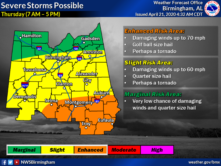
Pike Countians should brace for another round of potentially severe storms on Thursday.
The National Weather Service on Tuesday updated the risk for potential storms from marginal to enhanced for Pike and surrounding counties.
“There is still uncertainty about timing and strength of the system,” said Herb Reeves, Pike County EMA director. “The main threats are currently straight-line winds with tornadoes.
“However, if atmospheric parameters continue to increase, there would also be a more substantial increase in severe weather, including strong tornadoes.”
The estimated timing for the storms is 11 a.m .to 8 p.m. Thursday, although Reeves said that timeline likely would be updated as we get closer to the event.
The forecast comes while residents throughout Pike County continue to try to clean up from severe storms that left thousands of people without power overnight Sunday. The storms, with straight-line winds of up to 95 mph, toppled trees, downed power lines, ripped off roofs and awnings and left a swath of destruction across the county
Mayor Jason Reeves compared the scope of the power outages to the impact of Hurricane Opal in 1995. At the peak of the outage, more than 4,500 City of Troy Utility customers and more than 11,000 South Alabama Electric Cooperative customers were without power.
More News


SportsPlus
MLB Playoff Betting Lines and Picks Today | Oct. 16
The Los Angeles Dodgers and the New York Mets square off for one of many exciting matchups on…
WNBA Betting Picks: Thursday, Oct. 16
Wondering how you should bet on today’s WNBA game? Look no further. Below you’ll find computer predictions on…
How to Watch the WNBA Playoffs Today | Oct. 16
On a Wednesday WNBA playoff schedule that features just one contest, the New York Liberty and Minnesota Lynx…
Sun Belt Football Scores and Results – Week 8 2024
The Week 8 college football schedule includes six games with Sun Belt teams involved. Keep reading to get…
NFL Week 7 Picks Against the Spread, Tips and Predictions
There are 15 matchups on the NFL’s Week 7 schedule, with the Chiefs (+1.5) among the best bets…
-
Polls
 Loading ...
-
-