Tornadoes possible tonight
Published 9:29 pm Wednesday, April 17, 2019
Just four days after an EF1 tornado carved its way through Troy on Sunday, a very similar storm system is threatening Pike County once again.
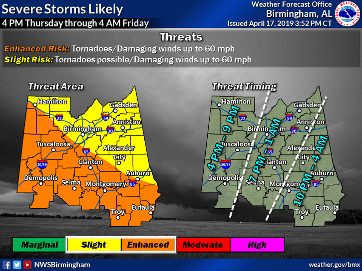
The National Weather Service in Birmingham is reporting that Pike County, along with most of Central Alabama, is now at an enhanced risk of severe storms beginning late tonight that could produce tornadoes and winds more than 60 miles per hour.
“Right now the timeline for us is between 10 p.m. Thursday night and 4 a.m. Friday morning,” said EMA Director Herb Reeves. “We’re in the same situation as we were Sunday with the potential for tornadoes and damaging winds.”
Similar to Sunday’s storm, Pike County was considered at a slight risk of severe weather before being upgraded to an enhanced risk as the storm system approaches.
That storm produced two EF0 tornadoes and one EF1 tornado in Pike County, with the strongest tornado cutting a path through Hunter’s Mountain Mobile Estates all the way to Three Notch Street.
Reeves said the one major difference of this storm is the timing.
“With this one it’s going to come at night, people are going to be asleep,” Reeves said. “It is extremely important that people have a way to wake themselves up, whether it’s a weather radio or they could sign up for Smart911 alerts.”
Reeves said residents need to take precautions regardless of how the forecast progresses Thursday.
“Don’t be so focused on whether the risk is enhanced or slight; know that the potential for a tornado is there and be as ready as you can be,” Reeves said.
Editor’s note: The Messenger will be monitoring this storm online and on social media.
More News


SportsPlus
Atlanta Falcons vs. Los Angeles Chargers Week 13 Tickets Available – Sunday, December 1 at Mercedes-Benz Stadium
The Los Angeles Chargers (0-0) travel to Mercedes-Benz Stadium on Sunday, December 1, 2024 to play the Atlanta…
Atlanta Falcons vs. New York Giants Week 16 Tickets Available – Sunday, December 22 at Mercedes-Benz Stadium
On Sunday, December 22, 2024, the Atlanta Falcons (0-0) and the New York Giants (0-0) match up at…
Atlanta Falcons vs. Minnesota Vikings Week 14 Tickets Available – Sunday, December 8 at U.S. Bank Stadium
On Sunday, December 8, 2024, the Minnesota Vikings (0-0) and the Atlanta Falcons (0-0) go toe to toe…
Atlanta Falcons vs. Las Vegas Raiders Week 15 Tickets Available – Monday, December 16 at Allegiant Stadium
On Monday, December 16, 2024, the Atlanta Falcons (0-0) meet the Las Vegas Raiders (0-0) at Allegiant Stadium.…
Atlanta Falcons vs. Dallas Cowboys Week 9 Tickets Available – Sunday, November 3 at Mercedes-Benz Stadium
On Sunday, November 3, 2024, the Atlanta Falcons (0-0) and the Dallas Cowboys (0-0) play at Mercedes-Benz Stadium.…
-
Polls
 Loading ...
-
-