HURRICANE MICHAEL: Storm could head toward Pike County
Published 10:45 pm Monday, October 8, 2018
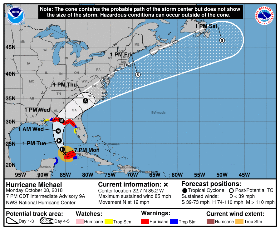
As of 8 p.m. Monday night, it was still unclear just what kind of weather impact to expect from Hurricane Michael in Pike County.
“The latest track has shifted somewhat westward, making the storm closer to our area,” said Herbert Reeves, interim EMA director, just after 8 p.m. Monday. “The concern is increasing for southwest counties. Any additional westward shifts would result in a significant impact to our area.“
The Emergency Operations Center (EOC) will be up and running Tuesday morning at 7:00 for officials from various departments to monitor the storm and make preparations.
City of Troy officials are also monitoring the storm and preparing for the worst.
“As Hurricane Michael moves north into the Gulf, we are preparing for the worst and hoping and praying for the best,” said Troy Mayor Jason Reeves. “If the track of Michael moves to the west, we could face very dangerous weather … EMA director Herb Reeves and I will talk (Tuesday) and begin to use the most current information to make decisions on Wednesday closings. The City will post updates as we have them.
“Please take this seriously and keep an eye and ear out for updates. The warm weather in the Gulf could cause this to be a very dangerous and volatile situation that can change quickly. Please pray for those on the coast and in the path wherever it may be and the first responders and utility and public works employees across the region.”
Herb Reeves said the forecast for Pike County had remained relatively unchanged through 8 p.m. Monday, with the storm still tracking to make landfall on the Florida panhandle Wednesday as a category 3 hurricane. Pike County was forecast at 8 p.m. Monday to have 1 to 3 inches of rain, with higher rainfall possible locally, and wind gusts of 30 to 40 miles per hour. “That’s still subject to change throughout the night and into the morning,” he said.
Residents should be preparing for the worst as well, Herb Reeves said.
“Residents need to go ahead and get prepared,” he said. “It’s better to be safe than sorry and be prepared. If it does take another westward shift, people are going to wake up without much time and realize they need to get prepared. Everyone needs to make sure they have gas in their cars and has plenty of food and water.”
Regardless of the weather impact locally, the storm is already having an effect on traffic and hotels in the area.
Fred Whiting, manager at the Courtyard Marriott in Troy, said the hotel is booked solid for the next two days after a rush of evacuees.
“It’s been very busy,” Whiting said. “We’re still getting calls as we speak. The phone has been ringing nonstop. We began getting calls this morning and we were sold out by probably noon.”
Employees at other hotels said they too have been receiving plenty of calls from evacuees.
Troy Police Chief Randall Barr said residents should expect a heavier flow of traffic throughout the day and into Wednesday as people make their way from the coast.
“There are already mandatory evacuations along the Gulf Coast,” Barr said. “Those people are going to be coming north to get away from the storm, so northbound traffic on U.S. Highway 231 and Alabama Highway 87 is going to be heavier than normal.”
Barr said the department is already preparing for the worst case scenario with the storm.
“We’re preparing for the worst and hoping for the best,” Barr said. “We’re making preparations to make sure we have additional staff here and to have vehicles fueled; we’ll have enough staff here to handle whatever may arrive. It’s always easier to back off of that then bring more folks in at the last minute. “
Gov. Kay Ivey declared a State of Emergency Monday afternoon to ensure emergency operations are able to move as needed as the storm arrives.
“Alabama is once again in the path of a hurricane, but I know Alabamians will once again come together and be prepared for whatever Michael may bring,” Ivey said. “On the state level we are prepared, now is the time for residents in south Alabama to review your emergency preparedness plans and also get prepared. (Tuesday) we will start seeing the effects of Michael and those in its path will need to take shelter by (Tuesday) evening. Please stay weather aware … for any forecast changes. Most importantly, heed all warnings and instructions from local authorities.”
Under the declaration, the Alabama Emergency Management Association will be assessing the damage from the storms.
““Hurricane Michael is forecast to become a major hurricane and it will produce wide-spread power outages and debris that will challenge our response and recovery in the southern and Wiregrass counties. Alabamians should always be prepared, but everyone needs to make final preparations now to be ready for Hurricane Michael,” Alabama Emergency Management Agency Director Brian Hastings said. “I am concerned about the cone of uncertainty as Hurricane Michael is leaning west (Monday). Residents and businesses in coastal Alabama must be vigilant and closely monitor the storm’s path and be prepared for a major hurricane.”
Residents can text “ALALERT” to 888777 to receive information for Hurricane Michael from the Alabama Emergency Management Agency.
Suggestions on how to prepare for a hurricane can be found at www.ema.alabama.gov and on Twitter by following @AlabamaEMA. Preparedness information can also be found at www.readyalabama.gov or by following Ready Alabama on Twitter at @readyalabama.
Editor’s note: The Troy Messenger editorial staff will be tracking this storm as it approaches the Gulf Coast and updating online both at troymessenger.com and on social media. Stay tuned Tuesday for breaking alerts.
More News


SportsPlus
Braves vs. Phillies: Betting Preview for August 31
Atlanta Braves (74-61) will play the Philadelphia Phillies (79-56) at Citizens Bank Park on Saturday, August 31 at…
How to Watch MLB Baseball on Saturday, August 31: TV Channel, Live Streaming, Start Times
The Los Angeles Dodgers versus the Arizona Diamondbacks is a game to catch on a Saturday MLB slate…
How to Watch the WNBA Today | August 31
Today’s WNBA slate includes just one game — the Connecticut Sun against the Washington Mystics. The WNBA is…
WNBA Betting Picks: Saturday, August 31
Wondering how you should bet on today’s WNBA game? Look no further. Below you’ll find computer predictions on…
Alabama State vs. North Carolina Central Predictions & Picks: Odds, Moneyline, Spread – Sunday, September 1
Which team is going to emerge victorious on Sunday, September 1, when the North Carolina Central Eagles and…
-
Polls
 Loading ...
-
-